Non so se esiste!!

Joined
May 6, 2020
Messages
6
Reaction score
0
Ho girato molti forum sui gps ma, non ho ancora trovato quello che cerco, forse perché non esiste.
Chiedo quindi venia anche a voi ed espongo il mio problema: esiste un GPS, un'APP o quacosa che, sia io sia in auto, a piedi, in bicicletta o con qualunque altro mezzo e in qualunque luogo mi trovi, strada, autostrada, sentiero mulattiera, prato bosco o altro, data delle coordinate, mi indica il percorso più breve per raggiungere il punto indicato dalle coordinate?
Allego foto per farvi capire cosa intendo.
Avendo le coordinate su una mappa, coma avere indicazioni per arrivarci?
Grazie [ATTACH = completa] 565 [/ attach]

English Translation :-

Hi.
Excuse my bad English, but I use a translator.
I posted a request in Italian from Italy because your forum was automatically translated.
I've shot a lot of gps forums but, I haven't found what I'm looking for yet, maybe because it doesn't exist.
So I ask you too and I explain my problem: is there a GPS, an APP or something that, whether by car, on foot, by bike or by any other means and wherever I am, road, highway, mule track, forest meadow or other, give me some coordinates, show me the shortest way to reach the point indicated by the coordinates or allow me to see if I'm getting closer ?
I enclose photos to make you understand what I mean.
Having the coordinates on a map, how do I get directions to get there?
Thanks
 

Attachments

  • 1.png
    1.png
    483.9 KB · Views: 245
There are two ways to direct you to a co-ordinate on a map :-
1) A straight line 'pointer' that will direct you to the location, using 'Left' and 'Right' to keep you moving in the correct direction
2) A Route that follows a road, path, track or other map feature, this will not direct you in a straight line and needs a map that has good details road, paths etc.
Do you require number 1 or number 2 above?

Traduzione italiana :-
Esistono due modi per indirizzarti a una coordinata su una mappa: -
1) Un 'puntatore' a linea retta che ti indirizzerà verso la posizione, usando 'Sinistra' e 'Destra' per farti muovere nella direzione corretta
2) Un percorso che segue una strada, un percorso, una traccia o un'altra funzione della mappa, questo non ti indirizzerà su una linea retta e necessita di una mappa con buoni dettagli su strada, percorsi, ecc.
È necessario il numero 1 o il numero 2 sopra?
 
Grazie per l'aiuto.
L'area in cui ho inserito le coordinate è abbastanza impraticabile - rocce, boschi, aree montane - ed è quasi impossibile seguire una linea retta per raggiungere il luogo indicato dalle coordinate.
Il secondo metodo è più adatto sempre che può funzionare anche quando non c'è strada o sentiero ma solo un percorso libero su cui camminare.
Come mappa uso MapSlow e questa è l'area in cui ho indicato le coordinate
[MapSlow link]

English Translation

Thanks for your help.
The area where I entered the coordinates is quite impractical - rocks, woods, mountain areas - and it is almost impossible to follow a straight line to reach the place indicated by the coordinates.
The second method is more suitable as long as it can work even when there is no road or path but only a free path to walk on.
As a map I use MapSlow and this is the area where I have indicated the coordinates
Code:
https://www.mapslow.eu/it/map/wrap/?close=treepanel/
 
Il secondo metodo è più adatto sempre che può funzionare anche quando non c'è strada o sentiero ma solo un percorso libero su cui camminare.

The second method is more suitable as long as it can work even when there is no road or path but only a free path to walk on.

This the problem, a GPS can't show to where to go if it has no path to follow, the only way to do this is to draw your own path using a computer running Google Earth or another map program and then download this 'Track' to the GPS

Traduzione italiana
Questo è il problema, un GPS non può mostrare dove andare se non ha un percorso da seguire, l'unico modo per farlo è tracciare il proprio percorso utilizzando un computer che esegue Google Earth o un altro programma cartografico e quindi scaricare questo 'Traccia "al GPS
 
If I use a pointer and, when I can't go straight because the terrain doesn't allow it, is it possible to deviate, get around the obstacle?
Does the pointer recognize my new position and tell me where I need to go to find the coordinates, or does it stay fixed on the starting track?
 
Does the pointer recognize my new position and tell me where I need to go to find the coordinates, or does it stay fixed on the starting track?

The GPS will plot a line from your starting point to the co-ordinates on the map screen, but you can also have a compass screen that will constantly point to the coordinates wherever you go, so if you do not move in a straight path to the co-ordinates it will update it's pointer to show the new direction
 
This is what I need!
Is there an APP to load on my smartphone or do I need to buy a GPS?
If I need to buy a GPS, which one do you recommend?
Thanks
 
Ciao.
Sto provando l'app GPS Waypoint Finder.
In fondo, ci sono le coordinate di dove si trova il telefono - casa mia -
45.480338 N
7.819383 E
Inserendoli in Google Maps, indicano perfettamente la mia casa, quindi la posizione del telefono è ok.
Seleziono nell'angolo in alto a destra la possibilità di inserire un nuovo waypoint
una casa a 70 metri da casa mia.
Latitudine N: 45.47772
Longitudine E: 7,82758
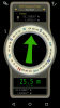
La freccia della bussola - gialla -, si attestava a 158 gradi SE e segnava una distanza di 65,8 m +/- 8,8 m.
Seguendo la freccia e indirizzando erroneamente la freccia, la freccia puntava sempre nella giusta direzione costringendomi a tornare indietro.
Mentre stavo andando, la distanza iniziale di 65,8 m è diminuita e quando sono arrivato a 20 m dalla casa è diventato verde come la freccia.
Era proprio quello che stavo cercando.
Ora devo vedere le altre funzioni.
Grazie, scusa se ti disturbo e fai una bella passeggiata!

English Translation
Hi.
I'm trying the GPS Waypoint Finder app.
At the bottom, there are the coordinates of where the phone is - my home -
45.480338 N
7.819383 E
By placing them in Google Maps, they indicate my home perfectly, so the position of the phone is ok.
I select in the upper right corner the possibility to insert a new waypoint
a house 70 meters from my house.
Latitude N: 45.47772
Longitude E: 7.82758
The compass arrow - yellow - stood at 158 degrees SE and marked a distance of 65.8 m +/- 8.8 m.
By following the arrow and misdirecting the arrow, the arrow always pointed in the right direction forcing me to go back.
As I was going, the initial distance of 65.8m decreased and when I got 20m from the house it turned green like the arrow.
It was just what I was looking for.
Now I have to see the other functions.
Thanks, sorry if I disturb you and take a nice walk!
 
GPS Waypoint finder is also my favourite, the first two smart phones I tried would not work with this App. because it requires both GPS and a built-in compass, the first two smart phones had no compass

Traduzione italiana
GPS Waypoint finder è anche il mio preferito, i primi due smartphone che ho provato non funzionerebbero con questa App. poiché richiede sia il GPS che una bussola integrata, i primi due smartphone non avevano bussola

Screenshot_2020-05-08-MOD.png
Click picture
 
Hi, everybody!
It's a beautiful day here and I thought I'd use the compass app to look for a rock with some rock carvings.
From home, I entered a new waipoint and asked myself: if instead of my home, I was in a different place, would the app keep my home as a starting point or would it generate new coordinates taking my new location as a starting point?
In a nutshell, the app "understands" that I moved and tells me how to get to the rock with the cups taking my new position as a starting point?

This is your stuff and I think it's very nice:
A woman without a man is like a fish without a bicycle.
We in Italy have this:
The woman is like the continents:
- at 20 years old she's like Africa, almost totally unexplored;
- at 30 she's like India, warm, mysterious and lush;
- at 40 she's like America, technically perfect;
- at 50, it's like Europe, completely in ruins;
- at 60 it's like Siberia, everybody knows where it is but nobody wants to go there.

Bye and have a good weekend
 
would the app keep my home as a starting point

No, GPS Waypoint Finder only has a 'Start' and 'End' point, the end point is the waypoint you entered (at the top of the screen) and the start point (at the bottom of the screen) changes as you move position, so every few seconds there is a new calculation from your current position to the waypoint

Traduzione italiana
l'app manterrebbe la mia casa come punto di partenza

No, GPS Waypoint Finder ha solo un punto 'Start' e 'End', il punto finale è il waypoint inserito (nella parte superiore dello schermo) e il punto iniziale (nella parte inferiore dello schermo) cambia mentre si sposta la posizione, quindi ogni pochi secondi c'è un nuovo calcolo dalla posizione corrente al waypoint
 

Members online

Back
Top